


What We Do
Las Vegas Valley Watershed
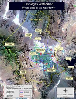 Las Vegas’ Hydrographic Basin encompasses 1,600 square miles, a basin that is recharged through precipitation and snowmelt from the surrounding mountain ranges running from the Spring Mountains to the west, Frenchman Mountain to the East, the McCullough Range to the South, and the Sheep Range to the North. The entire basin drains through the Las Vegas Wash into Lake Mead. The Upper Wash provides a natural drainage for approximately 500 square miles of the valley’s northern watershed. The remainder drains though a series of natural washes, transecting the City and intersecting the Las Vegas Wash above, in, and below the Clark County Desert Wetlands Park.
The DWC’s strategic plan focuses on advocacy for the development of solutions that will ensure adequate water supplies and infrastructure necessary to deliver water throughout the Las Vegas Valley, which is a region of 2.5 million people living by the availability of a water source (the Colorado River) that’s continually challenged by the community’s growth needs. The DWC, which is the sole private member of the Las Vegas Wash Coordination Committee, seeks to serve as a bridge to the citizenry in the community by participating with others to address solutions for the myriad of water issues that confront the Valley. The DWC’s strategic plan will of necessity be technical in nature and therefore require the input of subject area experts identify the priorities of the community that will need to be fulfilled. The community must be informed and updated through, among other avenues, the DWC regarding the community needs that are being addressed. Importantly, the DWC Board and its membership have been, are, and will continue to be entirely uncompensated volunteers in this process.
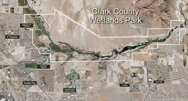
Click to download Watershed Map pdf file. Map provided by SNWA.
![]()
Upper Las Vegas Wash
The Upper Wash provides for the natural drainage of approximately 500 square miles of the valley’s northern watershed. The Wash is within a broad, northwest-southeast trending alluvial basin characterized by interbedding alluvial fans originating in the Las Vegas and Sheep ranges and the Spring Mountains. The Upper Wash is normally a dry, very wide, sandbed channel highly susceptible to erosion, headcutting, braiding, and lateral migration resulting from infrequent, but intense rain storms. The channel carries stormwater and runoff through the Clark County Wetlands Park, down to Lake Mead, providing an important floodway in the valley. It also contains unique riparian habitat that supports a large variety of vegetation and provides access to outdoor activities. The Wash and adjacent lands contain large numbers of paleontological sites, and is considered to be the most significant assemblage of late Pleistocene invertebrate fossil remains within the entire Great Basin. It also has been identified as important to Native American traditional uses.
The U. S. Department of Interior Bureau of land Management (BLM), Las Vegas Field Office, recently released the Draft Supplemental Environmental Impact Statement (SEIS) for the Upper Las Vegas Wash Conservation Transfer Area (CTA) within the Upper Wash. The SEIS is part of the formal process to identify the environmental consequences within the CTA, and to protect the area from development that may result in the damage of fossil formations, and sensitive cultural and plant resources. For more information please go to www.blm.gov/nv/st/en/fo/lvfo.html.
There are two protected areas within the Upper Wash; Tule Springs and the Eglington Preserve.
Tule Springs is a series of small springs that historically formed an oasis in the middle of the Mojave Desert. The Tule Springs site is listed on the National Register of Historic Places. It is a 1125 acre site that has provided substantial important data relevant to the paleontological history of the Great Basin. Tule Springs is protected by the National Historic Preservation Act of 1966. To learn more, visit www.tulespringslv.com.
The Eglington Preserve is a 300-acre parcel of public land that is managed to protect two special status plants; the Las Vegas Bearpoppy and the Las Vegas Buckwheat. The Preserve is within an active portion of the Wash and also contains fossils. The plants are listed as special-status species by the BLM and the Bearpoppy is classified as critically endangered by the State. The Eglington Preserve is protected through a Conservation Agreement between the BLM and state and federal agencies, and the City of Las Vegas.
For more information on the Upper Wash you can download our Spring 2010 newsletter.
Clark County Wetlands Park
The DWC was instrumental in securing the support and involvement of Clark County and the Southern Nevada Water Authority to assemble and set aside approximately 3,000 acres within the Wash for the purpose of a Desert Wetlands Park. As an advocacy organization, DWC contributed the long historical and deep technical perspective of its membership to this shared vision, developed over several decades.
Complete information on the Clark County Wetlands Park can be found at www.accessclarkcounty.com/depts/parks/locations/pages/wetlands.aspx
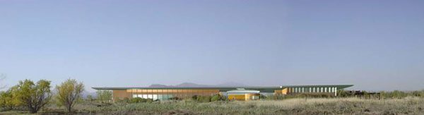
Virtual image of the new Nature Center

![]()